EARTH OBSERVATION FOR SUSTAINABLE DEVELOPMENT: HARNESSING THE POWER OF CHINESE SATELLITES

The Earth Observation for Sustainable Development: Harnessing the Power of Chinese Satellites is an international academic initiative aimed at training researchers, professionals, and students in the use of data from Chinese satellites to support the implementation of the Sustainable Development Goals (SDGs). Considering that today Earth Observation has become a strategic tool to address environmental, social, and economic challenges.
The course is divided into five Modules, with four Sessions in each as outlined below:
Module 1 - Chinese High-Resolution Radar Remote Sensing Satellites.
Module 2 - Chinese Fengyun Meteorogical Satellites and their Applications.
Module 3 - Chinese HaiYang Satellites and their Applications in Ocean Monitoring.
Module 4 - Chinese High-Resolution Optical Remote Sensing Satellite.
Module 5 - LuoJia Satellites Series and Applications.
The TUTORIAL VIDEO on Asynchronous Course Mode for the VELPLAT Project is designed to orient learners, showcase platform features, and provide standardized guidance that can be accessed at any time. Its purpose is to build confidence in navigating VELPLAT, empower learners to engage in self-paced study, and connect technical skills with the project’s broader goals of accessibility, scalability, and sustainable digital education.

United Nations Office that promotes international cooperation in the peaceful use and exploration of outer space. It supports countries — particularly developing nations — in accessing space technology, building capacity, and ensuring that space activities are conducted safely and sustainably.
b) Understand why radar satellites are essential for monitoring Earth, even under cloudy conditions or at night.
c) Recognize practical uses in agriculture, water resource management, natural disaster monitoring, and urban planning.
d) Name and locate the main Chinese radar satellites, understanding their role in international sustainability projects.
German geoscientist specializing in radar remote sensing and geoinformation, currently serving as Full Professor at Wuhan University’s State Key Laboratory of Information Engineering in Surveying, Mapping and Remote Sensing (LIESMARS) and Vice-Director of the International Academy of GeoInformation. He is internationally recognized for his work on Synthetic Aperture Radar (SAR), geodesy, and archaeological applications of Earth Observation.
Upon completion Session 2 - Module 1, participants will be able to:
a) Explain what SAR interferometry is, how radar signals are combined to measure surface changes, and how it differs from other Earth observation techniques.
b) Understand why interferometry is crucial for monitoring ground deformation, infrastructure stability, and environmental changes, even under cloud cover or at night.
c) Recognize practical uses in earthquake monitoring, landslide detection, glacier movement analysis, urban subsidence studies, and water resource management.
d) Name and locate key Chinese SAR satellites (such as Gaofen series), understanding their role in international cooperation and sustainable development projects.
German geoscientist specializing in radar remote sensing and geoinformation, currently serving as Full Professor at Wuhan University’s State Key Laboratory of Information Engineering in Surveying, Mapping and Remote Sensing (LIESMARS) and Vice-Director of the International Academy of GeoInformation. He is internationally recognized for his work on Synthetic Aperture Radar (SAR), geodesy, and archaeological applications of Earth Observation.
Upon completion Session 3 - Module 1, participants will be able to:
a) Explain what calibration and validation mean in the context of SAR satellites, including radiometric, geometric, and phase calibration methods.
b) Understand why calibration and validation are essential for ensuring reliable satellite data, supporting scientific research and operational applications.
c) Recognize how validated SAR data is applied in agriculture monitoring, disaster management, climate studies, and urban planning.
d) Name key Chinese SAR satellites (e.g., Gaofen series) and understand their calibration missions and international cooperation roles.
Associate Professor at Wuhan University’s State Key Laboratory of Information Engineering in Surveying, Mapping, and Remote Sensing (LIESMARS), recognized for his contributions to radar remote sensing, SAR image processing, and geospatial data analysis. He is an IEEE Senior Member and recipient of multiple provincial and national awards in China.
Upon completion Session 4 - Module 1, participants will be able to:
a) Explain how radar images are processed and interpreted, including techniques for extracting features such as land cover, water bodies, and infrastructure.
b) Understand why information extraction from radar imagery is critical for accurate Earth observation, especially in regions with persistent cloud cover or limited optical data.
c) Recognize practical uses in agriculture monitoring, flood mapping, deforestation tracking, urban expansion analysis, and disaster response.
d) Name key Chinese SAR satellites (e.g., Gaofen series) and understand their role in providing high-quality radar imagery for global projects.

Associate Professor at Wuhan University’s School of Remote Sensing and Information Engineering, internationally recognized for her expertise in Synthetic Aperture Radar (SAR) image processing and applications in agriculture, disaster monitoring, and geospatial analysis. She is a Senior Member of IEEE and has published over 70 SCI-indexed papers.
Upon completion Session 1 - Module 2, participants will be able to:
a) Explain what the Fengyun meteorological satellites are, their history, and their role in Earth observation.
b) Understand why Fengyun satellites are critical for weather forecasting, climate monitoring, and disaster preparedness worldwide.
c) Recognize practical uses such as tracking typhoons, monitoring rainfall, observing atmospheric composition, and supporting agriculture.
d) Name and differentiate between key Fengyun satellites (e.g., FY-2, FY-3, FY-4 series), understanding their specific missions and capabilities.
Professor specializing in materials science at the University of Science and Technology Beijing (USTB). His research on smart metallic and magnetoelectric materials is relevant to aerospace and satellite technologies, including meteorological satellites such as the Fengyun series. He is not directly part of UNOOSA but his work supports the kind of advanced materials used in space systems. Professor at Lima University.
Upon completion Session 2 - Module 2, participants will be able to:
a) Explain what satellite data policies are, including access rules, licensing, and international cooperation frameworks.
b) Understand why clear data policies are essential for ensuring transparency, accessibility, and effective use of Earth observation data.
c) Recognize services that provide processed satellite data for agriculture, disaster management, climate monitoring, and urban planning.
d) Name and describe key Chinese data distribution platforms, understanding their role in supporting global scientific collaboration.
United Nations Office that promotes international cooperation in the peaceful use and exploration of outer space. It supports countries — particularly developing nations — in accessing space technology, building capacity, and ensuring that space activities are conducted safely and sustainably.
Upon completion Session 3 - Module 2, participants will be able to:
a) Describe how Fengyun satellite data is processed and applied in monitoring extreme weather events such as typhoons, floods, and heavy rainfall.
b) Understand why Fengyun satellites are critical for early warning systems, disaster preparedness, and climate resilience.
c) Recognize practical uses in forecasting severe storms, tracking atmospheric changes, supporting agriculture, and managing water resources.
d) Name key Fengyun satellites (e.g., FY-2, FY-3, FY-4 series) and understand their specific missions in meteorology and climate science.
Professor researcher who has worked extensively on the application of Fengyun satellite data in extreme weather monitoring, with case studies focusing on typhoons, heavy rainfall, and severe convective storms. His work demonstrates how China’s Fengyun meteorological satellites provide critical real‑time information for forecasting and disaster management.
Upon completion Session 4 - Module 2, participants will be able to:
a) Describe how Fengyun satellite data is processed and applied to detect and monitor drought conditions, including vegetation indices and soil moisture analysis.
b) Understand why Fengyun satellites are critical for early warning systems, agricultural planning, and water resource management.
c) Recognize practical uses such as monitoring crop health, assessing water availability, supporting food security, and guiding policy decisions.
d) Name key Fengyun satellites (e.g., FY-3, FY-4 series) and understand their specific missions in meteorology and climate science.
United Nations Office that promotes international cooperation in the peaceful use and exploration of outer space. It supports countries — particularly developing nations — in accessing space technology, building capacity, and ensuring that space activities are conducted safely and sustainably.
Upon completion Session 1 - Module 3, participants will be able to:
a) Describe how Fengyun satellite data is processed and applied to detect and monitor floods, including rainfall estimation, soil moisture analysis, and water body mapping.
b) Understand why Fengyun satellites are critical for early warning systems, disaster preparedness, and climate resilience in flood-prone regions.
c) Recognize practical uses such as flood forecasting, emergency response planning, infrastructure protection, and water resource management.
d) Name key Fengyun satellites (e.g., FY-3, FY-4 series) and understand their specific missions in meteorology and hydrology.
Assistant Professor at the University of Hong Kong (HKU), specializing in satellite remote sensing of the ocean. His research focuses on how satellites like HaiYang (HY) provide critical data on ocean color, currents, algal blooms, and climate variability. The HaiYang satellites are China’s marine remote sensing program, launched since 2002 to monitor ocean dynamics and environmental change.
Upon completion Session 2 - Module 3, participants will be able to:
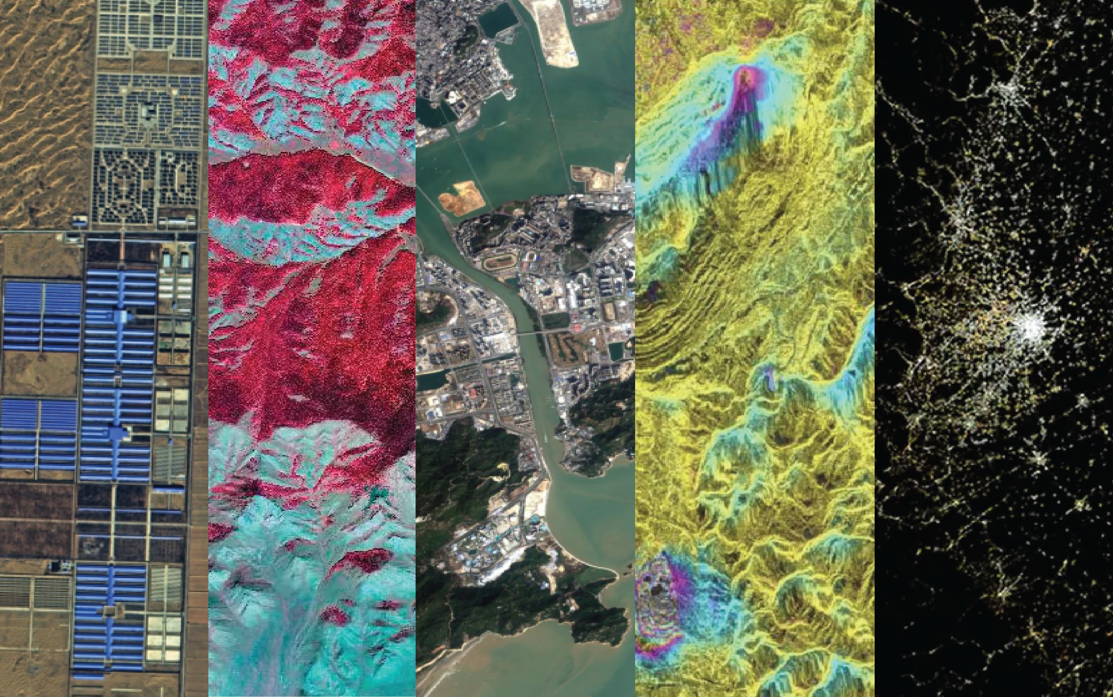
a) Describe the different types of data products available from Chinese satellites, including optical imagery, Synthetic Aperture Radar (SAR), ocean monitoring data, meteorological data, and nighttime light imagery.
b) Understand how to navigate official Chinese EO data portals, partner institutions, and cloud-computing platforms to search, discover, and download datasets.
c) Recognize how downloaded data can be applied to real-world challenges such as disaster risk reduction, water resource management, land use change analysis, and climate monitoring.
d) Identify key Chinese EO satellite systems (Gaofen, Ziyuan, Haiyang, Huanjing) and understand the types of data each provides.
United Nations Office that promotes international cooperation in the peaceful use and exploration of outer space. It supports countries — particularly developing nations — in accessing space technology, building capacity, and ensuring that space activities are conducted safely and sustainably.
Upon completion Session 3 - Module 3, participants will be able to:
a) Describe the types of ocean color and chlorophyll concentration data provided by HY-1 satellites and how these are used to detect red tide events.
b) Understand why HY-1 data is essential for monitoring harmful algal blooms, protecting marine ecosystems, and safeguarding fisheries and coastal communities.
c) Recognize practical uses such as early warning systems for red tides, fisheries management, aquaculture protection, and marine environmental research.
d) Name key HY-1 satellites (HY-1A, HY-1B, HY-1C, HY-1D) and understand their missions in ocean monitoring.
United Nations Office that promotes international cooperation in the peaceful use and exploration of outer space. It supports countries — particularly developing nations — in accessing space technology, building capacity, and ensuring that space activities are conducted safely and sustainably.
Upon completion Session 4 - Module 3, participants will be able to:
a) Describe the types of ocean color and chlorophyll concentration data provided by HY-1 satellites and how these are used to detect macroalgal blooms such as green tides and golden tides.
b) understand why HY-1 data is essential for monitoring macroalgal blooms, protecting marine ecosystems, and mitigating socio-economic impacts on fisheries and coastal communities.
c) Recognize practical uses such as early warning systems for green and golden tides, aquaculture protection, marine environmental research, and coastal zone management.
d) Name key HY-1 satellites (HY-1A, HY-1B, HY-1C, HY-1D) and understand their missions in ocean monitoring.
United Nations Office that promotes international cooperation in the peaceful use and exploration of outer space. It supports countries — particularly developing nations — in accessing space technology, building capacity, and ensuring that space activities are conducted safely and sustainably.
Upon completion Session 1 - Module 4, participants will be able to:
a) Describe the principles of high-resolution optical remote sensing, including spatial resolution, spectral bands, and imaging techniques.
b) Understand why high-resolution optical satellites are critical for accurate Earth observation, environmental monitoring, and resource management.
c) Recognize practical uses such as urban planning, agriculture monitoring, deforestation tracking, disaster response, and infrastructure development.
d) Name key Chinese high-resolution optical satellites (e.g., Gaofen series, Ziyuan series) and understand their missions in Earth observation.
AILONG MA Chinese researcher specializing in remote sensing applications for disaster management, particularly the use of high‑resolution optical satellite imagery to assess damage after earthquakes, floods, landslides, and other natural disasters. His work demonstrates how satellite data can provide rapid, reliable, and large‑scale information to support emergency response and recovery planning. YINHE LIU Chinese researcher in photogrammetry and remote sensing at Wuhan University (LIESMARS). He is best known for his work on Chinese optical remote sensing data access and licensing.
Upon completion Session 2 - Module 4, participants will be able to:
a) Describe how Chinese optical remote sensing data can be accessed through official portals, data centers, and international cooperation platforms.
b) Understand the rules and conditions governing the use of optical satellite data, including restrictions, permissions, and open-access initiatives.
c) Recognize practical uses of licensed data in agriculture monitoring, urban planning, disaster response, environmental management, and infrastructure development.
d) Name key Chinese optical satellites (e.g., Gaofen series, Ziyuan series) and understand their missions in Earth observation.
Chinese researcher in photogrammetry and remote sensing at Wuhan University (LIESMARS). He is best known for his work on Chinese optical remote sensing data access and licensing.
Upon completion Session 3 - Module 4, participants will be able to:
a) Describe how high-resolution optical imagery is processed and interpreted, including techniques for feature extraction such as land cover classification, vegetation indices, water body detection, and infrastructure mapping.
b) Understand why information extraction is critical for accurate Earth observation, especially in supporting decision-making for environmental management and urban planning.
c) Recognize practical uses in agriculture monitoring, deforestation tracking, urban expansion analysis, disaster response, and climate change studies.
d) Name key Chinese high-resolution optical satellites (e.g., Gaofen series, Ziyuan series) and understand their role in providing detailed imagery for global projects.
United Nations Office that promotes international cooperation in the peaceful use and exploration of outer space. It supports countries — particularly developing nations — in accessing space technology, building capacity, and ensuring that space activities are conducted safely and sustainably.
Upon completion Session 4 - Module 4, participants will be able to:
a) Describe how high-resolution optical imagery is processed to detect and quantify damage, including building collapse mapping, infrastructure disruption, and land cover change analysis.
b) Understand why satellite-based damage assessment is critical for rapid response, humanitarian aid allocation, and long-term recovery planning.
c) Recognize practical uses in earthquake aftermath analysis, flood damage mapping, wildfire impact assessment, and monitoring of urban resilience.
d) Name key Chinese high-resolution optical satellites (e.g., Gaofen series, Ziyuan series) and understand their role in providing timely imagery for disaster response.
Professor researcher specializing in remote sensing applications for disaster management, particularly the use of high‑resolution optical satellite imagery to assess damage after earthquakes, floods, landslides, and other natural disasters. His work demonstrates how satellite data can provide rapid, reliable, and large‑scale information to support emergency response and recovery planning.
Upon completion Session 1 - Module 5, participants will be able to:
a) Describe the evolution of the Luojia satellites (Luojia-1, Luojia-2, Luojia-3) and their unique contributions to remote sensing.
b) Understand why Luojia satellites are critical for advancing intelligent remote sensing, real-time data processing, and rapid information delivery.
c) Recognize practical uses such as nighttime light monitoring, urban planning, disaster response, agriculture monitoring, and climate studies.
d) Name key Luojia satellites (Luojia-1 for nighttime lights, Luojia-3 for intelligent imaging) and understand their missions.
Professor of Wuhan University is a leading expert in satellite video processing and intelligent remote sensing, and he has played a key role in the development and application of the Luojia‑Series Remote Sensing Satellites, particularly Luojia‑3 01, the world’s first intelligent remote sensing satellite with real‑time onboard processing capabilities.
Upon completion Session 2 - Module 5, participants will be able to:
a) Describe how raw Luojia satellite imagery is processed, including radiometric correction, geometric correction, and atmospheric adjustment.
b) Understand why data processing is critical for ensuring accuracy, reliability, and usability of high-resolution optical imagery.
c) Recognize practical uses such as urban expansion monitoring, agricultural yield estimation, disaster damage assessment, and nighttime light analysis.
d) Name key Luojia satellites (Luojia-1 for nighttime lights, Luojia-3 for intelligent imaging) and understand their missions in Earth observation.
United Nations Office that promotes international cooperation in the peaceful use and exploration of outer space. It supports countries — particularly developing nations — in accessing space technology, building capacity, and ensuring that space activities are conducted safely and sustainably.
Upon completion Session 3 - Module 5, participants will be able to:
a) Describe Luojia 3’s multi-mode imaging (video, frame-push, scan-push), sub-meter resolution, and on-orbit AI processing.
b) Understand why Luojia 3 is critical for real-time Earth observation, reducing the data-to-service cycle to under 8 minutes.
c) Recognize practical uses such as disaster response, urban monitoring, agriculture yield estimation, climate studies, and smart city services.
d) Explain how Luojia 3 fits into China’s “Oriental Smart Eye” constellation and integrates positioning, navigation, timing, remote sensing, and communication.
United Nations Office that promotes international cooperation in the peaceful use and exploration of outer space. It supports countries — particularly developing nations — in accessing space technology, building capacity, and ensuring that space activities are conducted safely and sustainably.
Upon completion Session 4 - Module 5, participants will be able to:
a) Describe how hyperspectral sensors capture hundreds of spectral bands, enabling detailed analysis of Earth’s surface materials.
b) Understand why hyperspectral imaging is critical for precise environmental monitoring, mineral exploration, agriculture, and disaster management.
c) Recognize practical uses such as vegetation health monitoring, water quality assessment, pollution detection, mineral mapping, and urban studies.
d) Identify these satellites, their missions, and their role in China’s Earth Observation constellation.
United Nations Office that promotes international cooperation in the peaceful use and exploration of outer space. It supports countries — particularly developing nations — in accessing space technology, building capacity, and ensuring that space activities are conducted safely and sustainably.
The purpose of the Final Assessment in Earth Observation for Sustainable Development – Harnessing the Power of Chinese Satellites goes beyond simply testing knowledge. It is designed as a bridge between theory and practice, ensuring that learners can confidently apply satellite data to real-world sustainable development challenges.
United Nations Office that promotes international cooperation in the peaceful use and exploration of outer space. It supports countries — particularly developing nations — in accessing space technology, building capacity, and ensuring that space activities are conducted safely and sustainably.
Provide practical knowledge focused on the access, processing, and application of optical and radar imagery, thereby promoting the dissemination of spatial information, the strengthening of technical capacities, and the construction of more resilient and sustainable societies within the framework of the global sustainability agenda.
Note:
If you are interested to be registered on the following course, please complete the application form with your personal information making click on the REGISTRATION button below and send it to receive a User & Password.

Availability: 2026-06-01 from to 2026-12-31
Mode: ONLINE RECORDED
Topics: 22
Lecturers: 22
Vacancies: